The valley of the River Mersey was created during the last ice age. Thick glaciers moved inland from what is now the Irish Sea, carving deep parallel iceways. The iceways were later occupied by the Mersey, the Dee, the mid-Wirral channel and the Alt–Ditton valley. The meltwaters of the glaciers formed the rivers which still flow today.
Origins of the River Mersey
The word ‘Mersey’ is probably Old English in origin. Maeres-ea meant border river, the border most likely referring to that between the kingdoms of Mercia and Northumbria.
Shape and Size
The River Mersey is 70 miles long, rising in Stockport at the confluence of the Rivers Tame and Goyt. In the centuries since it first gained its name, the Mersey still marked the boundary between counties. Lancashire historically lay to the north, with Cheshire to the south.
The Manchester Ship Canal has obliterated the course of the Mersey from Hollins Green to Rixton. The old river bed is visible outside Irlam and at Warburton.
The Mersey has a large tidal range – 8.4m (27’6”) – a range only topped by the Severn in south-west England.
Transport on the Mersey
The ferries that cross the River Mersey are Liverpool’s, perhaps the world’s – most famous river crossing. Monks from Birkenhead Priory founded the first Mersey ferry service in the 13th century. The Domesday Book (1086) records later services between Seacombe and the Pool. In 1317 a royal license gave permission to begin ferrying passengers from Woodside. Thus were created the three points between which most Mersey ferries travel to this day.
Other Liverpool to Wirral river crossings are underground. The Mersey Railway Tunnel opened in 1886, and was the first tunnel. This created a rail link from Liverpool to Birkenhead, going through Hamilton Square and Birkenhead Central to Green Lane. Eventually the Liverpool side extended to join up with Central Station in 1892. It terminated at a lower underground platform.
The Queensway Tunnel was the first road tunnel to open. It joined Liverpool with Birkenhead, and opened in 1934. The Kingsway Tunnel connected Liverpool to Wallasey by 1971.
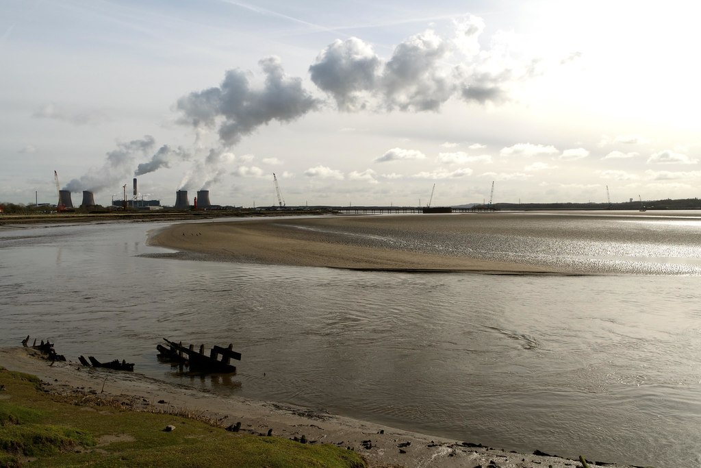
Industry and Pollution
From the 17th Century onwards, industry on the River Mersey expanded at a greater and greater speed. Industry began as small scale yards and mills, but grew into massive industrial structures like the Herculaneum pottery factory near the southern docks.
Later, the river provided a perfect place for other industrial works to use the water for cooling. Large amounts of industrial waste were simply dumped straight into the Mersey. The banks of the river also played a part: the relatively flat land on both sides meant good transport links were easy to build.
Coal came from Lancashire, salt from Cheshire and limestone from the Pennines. Merseyside acted as a magnet for many industries to gather. Liverpool, as a growing port, was developing widespread rail and canal links. The links with the industrial areas of north-west and central England encouraged further manufacturing plants .
Eventually, the Mersey became infamous as the most polluted river in Europe. More recently, however, efforts like the Mersey Basin Campaign have succeeded in cleaning up the river channel. Those species seen hundreds of years ago have returned to the Mersey, such as salmon, squid and cuttlefish.
Further Reading
River of Life, by David Ward
https://www.theguardian.com/society/2007/sep/19/guardiansocietysupplement.environment1
A large feature in the Guardian Society section (19 September 2007) tells of David Ward’s journey to find the source of the River Goyt, a Mersey tributary, and a walk along quite a length of the River Mersey itself. As well as the oft-celebrated salmon, local fishermen regularly catch cod as far upstream as Otterspool; the only reason they’ve not been found further up being that “we haven’t fished there”. Porpoises, grey seals and an octopus – predators – followed in the fishes’ wake. (Ward contributed to a chapter in the book Mersey: the River that Changed the World (Amazon UK), published in 2007 by Bluecoat Press)
David Flint
There never were any Saxons in Northern England and the Anglian Kingdom of Northumberland was confined to the east of the Pennines, and it was inhabited mostly by Celts.
David Flint
Tame means broad and in Modern Welsh it is Taf, Goyt was originally Gwith, which is Welsh and means narrow passage of water. The diphthong WI became broad O in the kind of Welsh spoken in Northern England of the time, later broad O became the diphthong OI, hence Goyt. Welsh in Northern England was gradually replaced by what is now called Scots which originated in Northumbria. Welsh was still being spoken in the 12th. century in Cumberland. Mersey probably just meant Marsh River. The notion that all the Celts of Northern England were exterminated by and replaced by Germans is just nonesense. Arthur de Gobineau. a French aristocrat wrote a book in which he claimed that the Franks were genetically superior to Celts meaning Gauls, and this racial superiority of Germans gave the French aristocrats the right to rule over the peasants, the aristocrats being of Frankish descent and the peasants Celtic. Germanism became popular in England during late Victorian times. Linz, who was Hitler’s mentor, advised all Germans to examine their back sides and if males their sexual organs to make sure that they do not possess Celtic or Slavic Negro features. Germanism is just rubbish and the River Mersey was not the border between Mercia and Northumbria. In fact it was the River Humber that was the border between Mercia and Northumbria.
David Flint
In medieval times Manchester was in Salfordshire, Machester was later seperated from Salfordshire. It was said that Manchester and Salford were seperated by the stroke of a pen and never were they conjoined again. It is obvious from this that these rivers including the Mersey did not always serve as boundaries.
David Flint
English people in the Midlands and Southern England with the exception of the South-West peninsula might well be members of the German master race, which is to say Anglo-Saxon master race, but Northern English people are not members of any German master race. All of this rubbish about Anglo-Saxons, master races, Germanism and so on should be rejected.
Martin
Hi David,
Thanks so much for your detailed comments on this Mersey article.
My comments in other articles about Anglo-Saxons inhabiting the area, and of the Mersey being a boundary are not to be taken as completely clear-cut historical situations.
Many boundaries in prehistoric up to Medieval times would have been a lot less well-defined than those we have today, although of course many would have been very clear-cut: hedges, ditches and rivers could all serve to separate one group of people from another. In this esne the Mersey may have been the furthest extent of a certain ill-defined territory, and been given its name even though it wasn’t a border as such.
Similarly, ‘Anglo-Saxon’ is often used to refer to the groups of Germanic people who came from the continent following the end of the Roman empire. Whether we can truly define their geographic origins is open to question – they would have includes much more than just the Angles, Saxons and Jutes of Bede’s Historia. There’s no question in my mind that the existing population and culture of Britain at the time of these migrations survived, and mixed with new cultures, and it is rather a Victorian view to label parts of a map as one tribe or another, and mark waves of incoming invaders who obliterate everything they overtake.
The whole of archaeology ad history is much more complex and intertwined than our traditional ideas of descendency and racial theories of genetics would allow.
David Flint
Northumbria or Northumberland means north of the river Humber. Angles were settled on the northern bank of the humber estuary by Vortigern. The Angles were settled there in order to protect the Humber region. Northumberland eventually reached as far as Lothian. The majority of the population were Celtic, the Angles were in a minority. Both Celts and Angles lived together peacefully, there is no evidence of genicide amywhere in Northern England. Northumbria was confined to East Yorkshirem which is east of the Pennines, not the west, unless of course if Yorkshire has not had some kind of geological migration to the west of the Pennines. From what is known the Mersey would have been the boundary between Rheged and Mercia, but never Yorkshire and Mercia. The ROCH in Rochdale is derived from Rheged.During victorian times Gobineaux’s Germanism became popular. Germanism is based upon the assumption that the Aryan race is superior to all other races, and that Germanic Aryans are superior to all other Aryans. In order to pander to this nonesense the lie that all the Celts in England were exterminated was created. Because of past Conservative Party policies there is a large number of non-whites in the UK, especially England, and I do not think that they would be happy to be classed as untermenscen or sub-humans on account of the colour of their skin. It is best to forget all about that Victorian Germanism and just say that the Mersey was the boundary between the Mercia and Rheged. I do not want to appear to be facetious but if you take a look in your old school atlas, if you still have it, you will notice that the river Humber happens to be east of the pennines and not west of them. Northumberland actually mean land north of the Humber and not land North of the Mersey.If the Germanist contention that the Mersey was the boundary between Mercia and Northumbria were true then Northumbria would surely have been called Northmersesia or Northmerseyland. Anyway we have to get on somehow with all of the non-white people and their descendents that the Conservatives induced to settle in England, and upsetting then with German supermen and women twaddle is not exactly the way to maintain good race relations. I have myself married an Asian lady. Oh sorry! In the 1960’s the BBC called them Pakistanis, which is why today all people from the Indian sub-continent are called Pakistanis or Pakis for short, so lets give the BBC a great hand clap for their contribution to racism in the UK. So according the the BBC I married a Paki. Thank you, thankyou BBC. What would we do without the Germanist racially biased BBC, good old Aunty, hats off to Aunty for all of her Germanistic clap-trap.
David Flint
Oh! I forgot to mention the Jutes. The word Anglo-Saxon should really be Anglo-Saxon-Jute, or perhaps the Anglo-Saxons were cannibals ate cooked and ate all of the Jutes thereby eliminating them and leacing just the Saxons and Angles, hence Anglo-Saxon and not Anglo-Saxon-Jutes.
David Flint
Mersey could just as easily have meant Marsh River, the Saxon word for river was EA, which is cognate to the Latin word Aqua. Some contend that the word MERE meaning a boundary mark is French as in Delamere Forest, which is French for ‘le forest de la mere meaning’, forest in modern French being foret.
And oh yes, I forgot to add that the reason why Welsh was still being spoken in parts of Northern England a thousand years after all of the Celts were exterminated is because Northern England was invaded by Welsh spaking Anglo-Saxons. Sorry for my spelling mistakes in the previous response.
Andrea Ku
Hi Martin
I just wanted to thank you again with the help and links. They are very useful and just what I have been after! Brilliant stuff. I shall cite with pleasure! Andrea
Martin Greaney
Hi Andrea,
Thanks so much for your kind comments! I love doing this, so am glad it’s helpful to you.
Martin
Leslie James Payne
Hi Martin!
Sorry this is another question!
pre WWII my Dad worked on the Pier Head, in the City Caterer’s Kiosk.
Do you know of any photographs of it? I do remember seeing the Kiosk when I was a boy. 1950’s to 1962. After which I became an Engine Room Boy on Esso Tankers. (S.S. Esso Coventy)
Do hope that you can help or point me in the right direction?
Further thoughts… any info on the Payne family from 34 Tiber St, Toxteth?
Les Payne, Liskeard, Cornwall.
Martin Greaney
Hi Les,
As so often, the Liverpool Picture Book comes to our aid. There’s a photo of the City Caterer’s, though it might be from a slightly later date than you’re interested in. Go to this page on L2-3 and search in the page for ‘coffee cart’. I’ve reproduced it below as it’s hard to spot in such a huge page.
Best wishes,
Martin
Freddy Bemand
Could anyone tell me about what date the mersey changed from a swamp to a full fledged river.I read somewhere that it was possible in Roman times to walk across from new brighton to crosby and that a great storm washed away the sand bar and allowed the marshland to flood.. Thankyou.
Martin
Hi Freddy,
I’ve also heard about the idea of walking from Wirral to Crosby, but I’m not sure that’s the latest thinking. The valley was most likely created by glaciers at the same time as the Dee valley and the shallower Alt/Ditton/Weaver line which are roughly aligned with the lower Mersey. The rivers would have naturally formed in these shallows.
However, sea levels change, and the Mersey Estuary has a tendency to silt up. Also, there are submerged forests all along the coast from Liverpool to Anglesey, so there was definitely much more dry land at one point. I can imagine that the Mersey could have been crossed on foot at certain times of year (like it could be at Hale Ford a few centuries ago).
So perhaps it was walkable in Roman / Iron Age times. If anyone has a link to where this story came from, I’d love to know so I can follow up!
Regards,
Martin
Freddy Bemand
Hi Martin,The book I got my info from is the “History of the Wirral Hundred” by William Mortimer,it’s at the back in the “memoir” cheers.
Martin
Ah, yes, I found a copy on the Internet Archive (for anyone else interested, it’s at https://archive.org/details/historyhundredw01mortgoog/page/n10/mode/2up – go to page 518 onwards to read about the submerged forest). I think that author suggests the forest would have been wiped away in a single ‘event’ (as he puts it), whereas I think now we’d see it as a long process. See https://www.visitsouthport.com/things-to-do/hightown-dunes-and-alt-estuary-p285201 for more details.
So to answer your original question, I think the last time you might be able to ford the Mersey around the Liverpool Bay area would be in the prehistoric period, perhaps the Bronze (2200-700BC) or Iron Ages (700BC – c.AD43).
Best wishes,
Martin